After a hearty breakfast, I left Page and headed due south toward Bitter Springs on the Navajo Reservation. Dropped down off the plateau on a very steep winding two-lane road. There was a pullout at the top where all cars and trucks were instructed to stop and check their brakes, etc. Three-quarters of the way down, weathered Navajo women had set up tables of jewelry and white clay & horsehair objects (bears, turtles, etc) in a large, scenic overlook. I liked the cedar seed necklaces, but rarely wear a necklace, so bought nothing. I was still high enough that the cars on Hwy 89A seemed as though viewed from an airplane.
 |
| The road down from the plateau; photo taken from the place where the Navajo women were selling their wares |
 |
| Plateau from which and valley into which I am descending; note the rim of the canyon running through it |
When I reached the bottom, I took a sharp right onto 89A north and drove through a valley. There was very little traffic or noise. I felt cocooned in the car just drinking in the immensity of the Vermillion Cliffs opposite across the valley several miles. Interestingly enough, I hooked a big horseshoe and eventually was driving along at the bottom of the Vermillion Cliffs, looking across the valley at the edge of the plateau I’d just driven along.
 |
| Vermillion Cliffs under which I will be driving as the road curves around |
Where the road crossed the Colorado at Marble Canyon, I stopped at the Navajo Bridge & Interpretative Center. The Colorado in this canyon was bright green, even without my sunglasses. It looked as though it had been dyed. Way down below were several zodiacs of people rafting this very calm section of the river. There are actually two bridges, an old one and a new one. You can walk across the old one and it makes a good spot for picture taking.
 |
| The green Colorado River |
I continued on past the “town” of Vermillion Cliffs (a few widely scattered single-wides), and stopped at the town of Cliff Dwellers—this area is not very original with its town names. Cliff Dwellers was an interesting place. Giant boulders had fallen from the high cliffs above, and ancient peoples had hollowed out under them or built around them to make themselves shelters. I would have been afraid to build here, thinking that another boulder was going to come down at any minute.
 |
| Boulders that have tumbled from the cliffs and hillsides |
At Jacob’s Lake I turned south on 67 and crossed the Kaibab Plateau, a beautiful, treed, grassy area with elk, mule deer, and ravens browsing on it. There was still snow under the trees in shady places. Oddly, the aspens on the hillsides come out of the ground and then twist up in a j. I wanted to get a photo of this, but the road was designed to discourage stopping—sloped, soft shoulders or no shoulders.
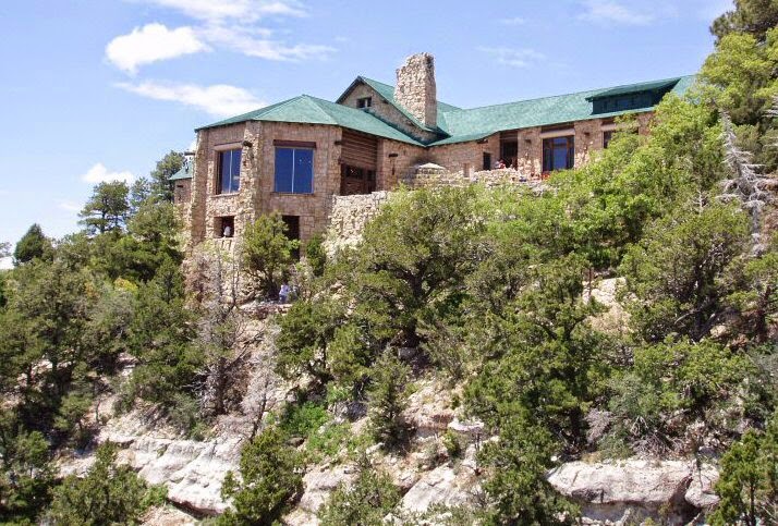
Maybe four cars passed me on the 44-mile drive in to the park. I thought: "Guess I am ahead of the season.” Guess again. When I got to the North Rim, the place was crawling with visitors, the parking lot nearly full and the lodge busy. The lodge sits right on the edge of the canyon, and visitors sat in rough-hewn versions of Adirondack chairs, feet on the stone wall, gazing toward the south rim of the canyon.
After getting settled in the lodge annex—cabin-like rooms in the woods—I walked to the lookout at the end of the Transept Trail and then to Bright Angel Point. Both end in a railed area on a rock hanging out over the canyon, and both required that I curb my acrophobia. Bright Angel is paved and only a quarter mile long, but toward its end it is on a spine of rock and drops off on either side of the trail—on the one side The Transept and on the other Roaring Springs Canyon.
 |
| Lodge Annex Porch |
 |
| Viewpoint at the end of Transept Trail |
 |
| Looking into Roaring Springs Canyon from Bright Angel Trail |
 |
| Paved Bright Angel Trail |
Flying off the cliffs were White-throated Swifts and Violet-green Swallows, as well as the ever-present ravens. Just after I got out of the car, a raven flew close to my head and gave its raucous hoarse croak. I jumped a foot. In vain I looked for the California Condors that were successfully released on the North Rim. Would have loved to see one of these enormous birds with a 10-foot wingspan. If you do get so lucky, you must report your sighting and the bird’s wing number to a ranger.
After exploring the lodge, the Visitor’s Center, and walking the Bright Angel, I caught lunch (a salad) at the Lodge Deli and then got myself situated in my room. On the way back to the room I saw and photographed a Kaibab Squirrel, a close relative to the Abert’s Squirrel but with a pure white tail and found only at the North Rim.
 |
| My blurry pic of the Kaibab Squirrel; below one from the Internet that shows the animal more clearly |
 |
| Kaibab Squirrel (Internet) |
I have had a cold since my freezing night in Singletree and find myself breathless at these high altitudes (North Rim is 8,500 feet and I was nearly at 9,600 feet in the Dixie National Forest Singletree Camp- ground). Suddenly I felt nauseous on top of it all. I whined to Jeff for a bit (after four unsuccessful connections where we’d be cut off mid-word), then typed up this journal. I was in bed again by 8 PM.


No comments:
Post a Comment