
3/10/2014
Day #1 — Stillwater, OK to Clayton, NM--May 23, 2011
Left Stillwater Monday, May 23, about 8 o’clock and spent my first night at Clayton Lake State Park in Clayton, New Mexico. (Sue, you and I and Marsha came through Clayton on our way back from Taos last year. It’s the place where the two Mexican guys opened their shop and fixed our flat on a Sunday.)
Nothing much to look at across the panhandle but yucca, windmills, and wind farms, some roadside flowers, and many fields of wheat and canola. Some of the wheat is already a ripe golden brown, and some of the hay fields have already been mowed and baled.
Much roadwork as they are resurfacing large sections of OK-51 west. I tooled along thinking of Katie Mussett giving birth to a daughter, Sara Kay, May 22, the day after my birthday. Thought about my birth and my mother and about the births of Jessica and Lucy. How lucky we are to have been born in a wealthy country to kind parents who could feed, clothe, and educate us.
Stopped briefly in Guymon for lunch. Made myself a sandwich in the little park behind the visitor’s center there. Arrived at Clayton Lake SP about 3 o’clock. It is about 12 miles northwest of Clayton and one has to drop off a plateau (quite literally, I was wishing for a parachute) and travel across a valley to get to it. There were many pronghorn antelope in the valley.
The CLSP has “one of the best dinosaur track sites in the world,” so after setting up camp, I walked to and across the dam to view them. The SP is also an IBA, Important Bird Area. I saw only barn swallows, turkey vultures, lark sparrows, and many western kingbirds chattering in the trees and brush. A pair of barn swallows had a nest in the canopy over my picnic table. They were very upset with me. The literature says that Golden Eagles are common, also, but I saw none.
.JPG)

When I arrived, temps were in the mid 80s and the wind was fierce. CLSP had a ban on all outdoor fires, so that, combined with the wind, nixed a hot supper. I had sardines, crackers, cheese, and an apple instead. I thought the wind might blow my staked tent into the lake at one point. Made putting up and taking down the tent interesting. too.


The kingbirds woke me at 6 AM. It was cold and windy, so after dressing in jeans, long-sleeved tee, and a sweatshirt, I was off. I picked up a loaf of bread, Windex, and paper towels at a supermarket—and coffee and a doughnut at a CS—and was on the road by 8 AM again—now on Route NM-87N to US-25N to CO-160W through Colorado.

The dragon pic below is of a restaurant in town, a nondescript place with a great decoration. I think the welder is local as there were other metal sculptures about town.The road below and the views beside it are through the valley I traveled to the Park, and the last two pix are of Clayton Lake. There were campsites and boat ramps nearly all of the way around it.


Nothing much to look at across the panhandle but yucca, windmills, and wind farms, some roadside flowers, and many fields of wheat and canola. Some of the wheat is already a ripe golden brown, and some of the hay fields have already been mowed and baled.
Much roadwork as they are resurfacing large sections of OK-51 west. I tooled along thinking of Katie Mussett giving birth to a daughter, Sara Kay, May 22, the day after my birthday. Thought about my birth and my mother and about the births of Jessica and Lucy. How lucky we are to have been born in a wealthy country to kind parents who could feed, clothe, and educate us.
Stopped briefly in Guymon for lunch. Made myself a sandwich in the little park behind the visitor’s center there. Arrived at Clayton Lake SP about 3 o’clock. It is about 12 miles northwest of Clayton and one has to drop off a plateau (quite literally, I was wishing for a parachute) and travel across a valley to get to it. There were many pronghorn antelope in the valley.
The CLSP has “one of the best dinosaur track sites in the world,” so after setting up camp, I walked to and across the dam to view them. The SP is also an IBA, Important Bird Area. I saw only barn swallows, turkey vultures, lark sparrows, and many western kingbirds chattering in the trees and brush. A pair of barn swallows had a nest in the canopy over my picnic table. They were very upset with me. The literature says that Golden Eagles are common, also, but I saw none.
When I arrived, temps were in the mid 80s and the wind was fierce. CLSP had a ban on all outdoor fires, so that, combined with the wind, nixed a hot supper. I had sardines, crackers, cheese, and an apple instead. I thought the wind might blow my staked tent into the lake at one point. Made putting up and taking down the tent interesting. too.
The kingbirds woke me at 6 AM. It was cold and windy, so after dressing in jeans, long-sleeved tee, and a sweatshirt, I was off. I picked up a loaf of bread, Windex, and paper towels at a supermarket—and coffee and a doughnut at a CS—and was on the road by 8 AM again—now on Route NM-87N to US-25N to CO-160W through Colorado.
The dragon pic below is of a restaurant in town, a nondescript place with a great decoration. I think the welder is local as there were other metal sculptures about town.The road below and the views beside it are through the valley I traveled to the Park, and the last two pix are of Clayton Lake. There were campsites and boat ramps nearly all of the way around it.
3/09/2014
Day #2-- Capulin Volcano, NM & Great Sand Dunes NP, CO--May 24, 2011
I’m in a Super 8 in Durango, CO, so can send an update. Was supposed to be in the United Campground of Durango but the weather is not cooperating. Big thunderstorm as I write.
I crossed three passes and made two side trips today. The first side trip was to Capulin Volcano National Monument, where I bought a National Park Pass—only $10 for a lifetime senior pass.
Wow. If I thought Scott Mountain was a scary climb, this one topped it. No guardrail, no rocks, no retaining wall, the white line at the very edge of the drop-off at times. I crept up nearly in the center of the road. No one was around so it didn’t matter. The top had an elevation of 7,877 feet.

At the top it was cold and blustery, so I added a jacket to my ensemble and walked the mile around the rim. Puff puff. Then I walked down to the volcano’s center. Puff puff puff. Saw a couple of ravens, mockingbirds, and a Pinyon Jay.
Next, I stopped in Raton, got gas, and washed the car windows with the Windex I’d bought. CO-25N has a 75 mph speed limit but also has “Share the Road” signs and blinking marquees that caution drivers to be aware of cyclists and bikers. Crazy!
Climbed over La Veta Pass and decided that it would not have been too bad on my bike. It’s two fairly short, gentle climbs with a rolling section between. The downhill would have been fantastic as it seemed to go on forever.
My next stop was Great Sand Dunes National Park. From a distance it does not look like much, but up close, the dunes are HUGE. Many busloads of kids were there, and a long string of people were climbing to the top of the tallest dune. Not I. It’s like walking in soft, deep beach sand. Would have been an Achilles tendon killer (maybe even a Susan killer) had I attempted it.


The weather was getting colder and the clouds more menacing. On my way out of the park and back to CO-106, two black storm clouds came sweeping toward me across the prairie. I got a few drops and tumbleweeds were flying, but I was right on the edge of the heavy wind and rain so missed most of it. Talked to Jeff earlier and he described the big tornado that tore through south of Stillwater today. I hope everyone is safe and unscathed.
My next stop was Wolf Creek Pass. When I started up, it was raining pretty steadily. About halfway up, the rain turned to snow and the temp dropped to 32F on the nose. The snow turned to a whiteout, and they were doing construction in places, so it was a bit dicey. But, when the snow abated a bit, one could see deep, pure white snow between the evergreens. Very beautiful.
I stopped at a lookout just before a big s-curve on the way down. It wasn’t snowing or raining there, but the clouds over the mountains were still black with potential. I don’t think I could have climbed Wolf Creek Pass on my bike or in anything but a lawn chair in the back of a pickup (inside joke). It is 10 miles of very steep (9% in places) twisty road, no shoulder on the steep spots, and steep with a hairpin turn going down. Trucks had to stop at a checkpoint, were restricted to low gear and 25 mph.There were two runaway truck ramps on the way down. Also a gorgeous big waterfall.


Well that’s it. Time now to rest in a comfortable bed. Did I mention that I grabbed the g.d. Theramarest (out of 5 that we own) that will not hold air? I refuse to buy another one. I have a 3/4 one with me and it will suffice.
I crossed three passes and made two side trips today. The first side trip was to Capulin Volcano National Monument, where I bought a National Park Pass—only $10 for a lifetime senior pass.
 |
| Internet aerial photo of Capulin Volcano |
At the top it was cold and blustery, so I added a jacket to my ensemble and walked the mile around the rim. Puff puff. Then I walked down to the volcano’s center. Puff puff puff. Saw a couple of ravens, mockingbirds, and a Pinyon Jay.
 |
| View from the top of the volcano |
 |
| View from the top of the volcano in another direction |
 |
| Rim of the volcano from other side; note the trail down into the caldera |
 |
| Looking down to the bottom of the caldera |
Climbed over La Veta Pass and decided that it would not have been too bad on my bike. It’s two fairly short, gentle climbs with a rolling section between. The downhill would have been fantastic as it seemed to go on forever.
My next stop was Great Sand Dunes National Park. From a distance it does not look like much, but up close, the dunes are HUGE. Many busloads of kids were there, and a long string of people were climbing to the top of the tallest dune. Not I. It’s like walking in soft, deep beach sand. Would have been an Achilles tendon killer (maybe even a Susan killer) had I attempted it.
 |
| Dunes looking small from a distance compared with the snow-capped mountains |
 |
| People--looking like ants--climbing the largest dune |
The weather was getting colder and the clouds more menacing. On my way out of the park and back to CO-106, two black storm clouds came sweeping toward me across the prairie. I got a few drops and tumbleweeds were flying, but I was right on the edge of the heavy wind and rain so missed most of it. Talked to Jeff earlier and he described the big tornado that tore through south of Stillwater today. I hope everyone is safe and unscathed.
My next stop was Wolf Creek Pass. When I started up, it was raining pretty steadily. About halfway up, the rain turned to snow and the temp dropped to 32F on the nose. The snow turned to a whiteout, and they were doing construction in places, so it was a bit dicey. But, when the snow abated a bit, one could see deep, pure white snow between the evergreens. Very beautiful.
I stopped at a lookout just before a big s-curve on the way down. It wasn’t snowing or raining there, but the clouds over the mountains were still black with potential. I don’t think I could have climbed Wolf Creek Pass on my bike or in anything but a lawn chair in the back of a pickup (inside joke). It is 10 miles of very steep (9% in places) twisty road, no shoulder on the steep spots, and steep with a hairpin turn going down. Trucks had to stop at a checkpoint, were restricted to low gear and 25 mph.There were two runaway truck ramps on the way down. Also a gorgeous big waterfall.
 |
| View past hoodoos in the making on the S-curve on the way down Wolf Creek Pass; road to the left is mine |
 |
| Roadside waterfall on way down Wolf Creek Pass |
Well that’s it. Time now to rest in a comfortable bed. Did I mention that I grabbed the g.d. Theramarest (out of 5 that we own) that will not hold air? I refuse to buy another one. I have a 3/4 one with me and it will suffice.
3/08/2014
Day#3—Durango-Silverton Narrow GaugeTrain & Mesa Verde, CO--May 25, 2011


In front of me were John & Carol, a couple of Harley motorcycle riders from Virginia City, NV. They were in an RV and not on their motorcycles, however. John was a firefighter so we talked FPP & IFSTA for a bit. He wore a cowboy hat and responded to everything with “Yes ma’am.” Made me feel old, but he insisted that he was a south’n boy and that was his way of showing respect . . . no matter the age of the woman. Uh-huh.
It was a long chug to Silverton—3½ hours—so we looked at the wildlife (mule deer, elk, prairie dogs [near Durango] and some people at Wild Camp hissing from treetop to treetop beside the train on zip lines) took a lot of pix out the open train windows, drank bloody Mary’s (J & C) and coffee & Baileys (me), and got acquainted.

There is a bike race in mid-May called The Ironhorse Classic. Cyclists race from Durango to Silverton over Hwy 550, which was built in 1920—long after the railroad was built in 1881. The race took place on May 24th this year, so I just missed it.
When we got to Silverton—a mining town at 9,320 feet surrounded by snow capped 13,000-foot Sultan Mt., Kendall Mt., and Storm Peak, and with wide cowboy-movie dirt streets and a lot of gaily painted store fronts and tourist shops—we were waved into Natalia’s 1912 Restaurant where I had a pesto chicken sandwich and slaw for lunch. Then I walked about the town taking pix and poking about in the shops.

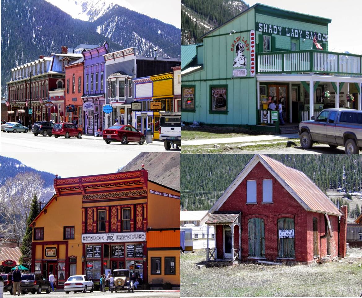

 |
| Note the woman in the top right photo beckoning those who just debarked the train to come to Natalia's Restaurant for lunch. That I and several others did. |
The trip back took another 3½ hours. This was 3½ hours too long for me. I didn’t realize that there was the option of taking the bus back and cutting the return in half. We did not get back to Durango until 7:30 PM! I then raced to Mesa Verde (only 40 miles away) to set up and fix myself something to eat before dark.
Day #3--Mesa Verde, CO
May 25 -- 929 miles
Mesa Verde was a surprise, the road to it a long uphill twist to an elevation of 6,000 to 8,000 feet. I had always envisioned it in the cliff faces before a wide grassy valley. I camped at Morefield Campground within the park. The funny thing is that I registered at the store, and then drove a big 1-mile loop to end up camped behind the store (see schematic above). Unknowingly, I chose the perfect campsite, the path opposite leading over a hill to the store, showers, laundry, and bathrooms (really roughing it here); and the place for my tent was thickly grassy.

I love my Hubba Hubba tent and erected it in a flash. As I was doing so, five mule deer came to call. They were not 10 feet from me and seemingly unfazed by my presence. No sooner had I gotten the tent up and my gear inside than Chris and Debbie from Tucson invited me to come over and have a glass of wine with them. I took my camp chair over and we sat before a fire and drank Sangria and some other cheap red wine from a box until about 11 p.m. Debbie worked in the Tucson University of Arizona bookstore and Chris was returning to school to get a degree in archeology.


I slept cold in the tent, despite wearing sweats and knee socks. Must get a new sleeping bag as well as a new Thermarest.
3/07/2014
Day #4—Mesa Verde Tour & Rodeway Inn Monticello, UT--May 26, 2011
1076 miles on the odo
Got up at 6:30 this AM and broke camp before going to the campground café (told you I was roughing it) and having a pancake breakfast. At breakfast I met an interesting couple from Chicago. She was a travel journalist but I don’t remember what he did other than grow container gardens. We had breakfast together and then they went on one tour and I on another. Cannot remember their names.
The tour leader, Sharon, had been on the job only three days, but she was knowledgeable and a great driver on these cliff-hanging, s-curved roads. She’d been a driver’s ed teacher in a previous life. There were only seven of us (three couples and me—one couple from France with little English) which made for a good group.
If you haven’t been to Mesa Verde, you really must go. It is stunning how these ancient (550 -1300 AD) Puebloan people built their houses and granaries in cliff-side niches and holes in the ground. Just shaping the sandstone and getting it up and down would have been a feat. They used hand and toe holds to get to the mesa above to tend their crops, and I shudder to think of it. Wonder at what age the children were taught to monkey climb out.
We ate our lunch in a picnic grove, and then returned the 17 miles back to the campground in late afternoon. I immediately took off for Monticello. My eyes were very tired after so much sun, binocular, and camerawork, so on arrival in Monticello, I took a nap, took a shower, and fixed myself a hot meal from my camp kitchen, in that order. Then I got out the bike, pumped the tires, rounded up my bike duds, and prepared for my ride to Moab tomorrow.
Temps were in the low 70s today with a south wind. Hope that holds for tomorrow also. Cannot report from Moab as I will not have my computer etc., but will be back at this motel on the 28th, and shall recount my ride to and from then.

The series of doorways above led one into the first ruin we stopped at, which was chronologically one of the last built. It shows the influence of the Chaco Canyon peoples who were very advanced architecturally.
Got up at 6:30 this AM and broke camp before going to the campground café (told you I was roughing it) and having a pancake breakfast. At breakfast I met an interesting couple from Chicago. She was a travel journalist but I don’t remember what he did other than grow container gardens. We had breakfast together and then they went on one tour and I on another. Cannot remember their names.
The tour leader, Sharon, had been on the job only three days, but she was knowledgeable and a great driver on these cliff-hanging, s-curved roads. She’d been a driver’s ed teacher in a previous life. There were only seven of us (three couples and me—one couple from France with little English) which made for a good group.
 |
| An unflattering pic of Sharon |
We ate our lunch in a picnic grove, and then returned the 17 miles back to the campground in late afternoon. I immediately took off for Monticello. My eyes were very tired after so much sun, binocular, and camerawork, so on arrival in Monticello, I took a nap, took a shower, and fixed myself a hot meal from my camp kitchen, in that order. Then I got out the bike, pumped the tires, rounded up my bike duds, and prepared for my ride to Moab tomorrow.
Temps were in the low 70s today with a south wind. Hope that holds for tomorrow also. Cannot report from Moab as I will not have my computer etc., but will be back at this motel on the 28th, and shall recount my ride to and from then.
The series of doorways above led one into the first ruin we stopped at, which was chronologically one of the last built. It shows the influence of the Chaco Canyon peoples who were very advanced architecturally.
 |
| These cliffs were near the road on the way to the cliff dwellings. My group stopped here for a history lesson and to look into the Montezuma Valley. Hundreds of thousands of ancient Publoan peoples inhabited this valley and then moved for some unknown reason to the protection of the cliffs and grew corn on the plateau above the cliffs. |
 |
| The first ruins we looked at were not tucked into the cliffs but built atop the mesa. The horses in the photo above belong to someone in the valley who does not feed, ride, or vet them and they have gone wild (feral). Each time he rounds them up and takes them miles away, they return to Mesa Verde National Park. There are about 30 left in the herd. The Park would like to be done with them but visitors like me love to see them. The foal is about 3 weeks old. |
 |
| We walked down to Spruce Tree House and got a good close-up view of the architecture. The two kivas at this site were roofed and one could climb down into one of them (ladder top left). The rooms extended far back into the cave niche, the ceilings still blackened with soot. The black streaks on the cliff face in the bottom right photo are not soot but a type of algae. Left bottom photo shows three corn grinding areas.
Below are some photos of Cliff Palace and some other cliff dwellings along the same canyon wall. Cliff Palace has 150 rooms and 23 kivas. It is thought to be the largest cliff dwellings in North America. the bottom two photos show the canyon entire and how the mesa atop the cliffs looks today after a series of fires.
 Arrived at the Rodeway Inn with plenty of time to rest and relax and catch up on my journal. It's plain jane but clean and warm.  |
Subscribe to:
Posts (Atom)